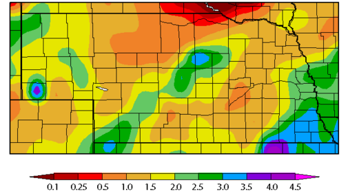
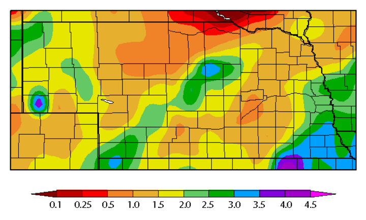
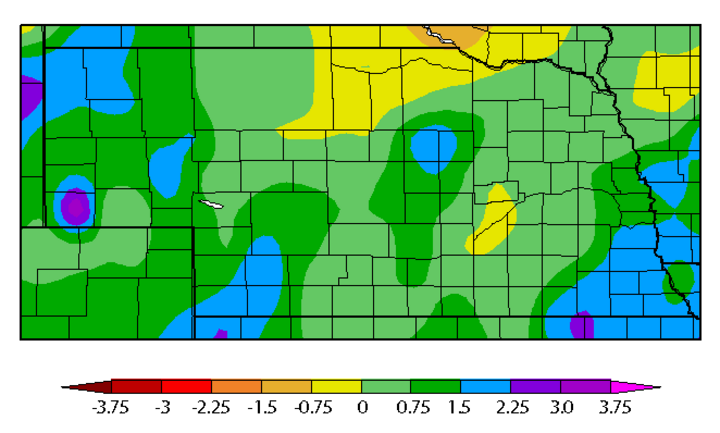
Storm activity since Friday, March 24 has reversed some of the late winter dryness across the state, but much more rain is needed to reduce abnormally dry and moderate drought conditions across south central and southwest Nebraska. This recent rainfall was sufficient to eliminate abnormal dry conditions across southeast Nebraska from Fairbury to the Iowa border.
Sufficient moisture also fell across the northwestern half of the southwest corner of the state to eliminate abnormally dry conditions from just southwest of North Platte through the central Sandhills. A Hayes Center NeRAIN observer reported 4.73 inches from March 24 to April 3. Numerous locations in the southwest received more than 3 inches as did an area from Beatrice east to the western Iowa border.
The sun has been conspicuously absent across most of Nebraska the past two weeks as a steady stream of storm systems has rolled across the central U.S. During this pattern, very welcome moisture was received throughout the wildfire burn areas of southwestern Kansas, western Oklahoma, and the Texas Panhandle. Even with numerous locations reporting over 4 inches, rainfall was steady with minimal runoff.
For the time being, the wildfire risk across most of the central Plains has been eliminated; however, a return to above normal temperatures and below normal precipitation will increase the risk again. This active weather pattern will likely slow the pace of initial corn planting. More extensive planting delays are possible if the current model depiction of short-term weather conditions comes to fruition.
The system currently working through the central Plains Region April 4-5 is projected to intensify into a late spring storm over the western Great Lakes region. This will help carve out a deep upper air trough over the eastern U.S., while allowing for an atmospheric ridge to build into the central Plains for the remainder of this week and most of this coming weekend.
A weak wave is projected to slide across the state April 9 as the upper air ridge shifts east of Nebraska. Only light moisture is projected, with northeast and east central Nebraska projected to have the best chance for moisture. A more potent system is projected to develop April 11-12. It appears this system will have enough cold air to bring a mixture of rain and snow, possibly all snow, to portions of northwest and north central Nebraska. The rest of the state is projected to receive rain.
Another weak system is forecast to move across the state April 14 with light precipitation possible statewide. The GFS model forecast a potent weather system to develop April 16-18, which is right at the end of the 16-day forecast period. We will wait for this trend to be verified by future model runs, but if it does, heavy rainfall is probable and accumulating snowfall would be favored for the western two-thirds of Nebraska.
A more favorable forecast for planting may develop during the second half of April. The Climate Prediction Center’s three- to four-week outlook calls for above normal moisture across the northern tier of states from the Pacific Northwest through the western Great Lakes. This would place the northern third of the state in a favorable position for moisture and southern Nebraska in a much drier pattern. Temperatures are projected to remain above normal from North Dakota southward though Texas. Essentially all areas east of the Rockies are forecasted to experience above normal temperatures during the second half of April.
A large area of below normal moisture is projected east and south of area from central Texas and Oklahoma eastward through northeastern North Carolinas. There has been some drought recovery across the southern Mississippi River valley, but forecasts for drier than normal conditions will bear watching for further deterioration during May.
