It has been exceptionally wet since mid April with south central and southwest Nebraska receiving enough moisture to eliminate short-term dryness concerns that dominated the early February through mid-April period. Moisture data from NERain stations show that at least 253 stations recorded over 5 inches of moisture April 15-30. Arcadia, in Valley County in central Nebraska, had 10.3 inches, the highest two-week total, but it wasn’t unusual: 38 locations recorded more than 8 inches of moisture.
The heavy moisture is eerily reminiscent of last year when heavy rainfall in late April brought widespread flooding to southeastern Nebraska. It also marked a long stretch of rainfall that resulted in prevented planting due to insufficient drying between storm events. Thankfully, areas receiving the most rainfall had shown soil moisture depletion in the top two feet of the profile. Even though fields are wet, large scale soil erosion has not been reported.
Throughout my fall and winter talks, I mentioned that spring precipitation statistics indicate an increased tendency for above normal moisture during El Nino springs across much of the central High Plains region. The February-April period had the highest odds of above normal moisture statewide, while the March-May period had the second highest odds. Remember that the “above normal” moisture refers to the entire three-month period, which means the period average is wet. Within the three-month period there can be distinct wet and dry periods.

El Nino snowfall statistics indicate south central, southwest, and the southern half of the Panhandle usually experience above-normal snowfall, with the March-May period showing the highest deviations from normal. Most of this region averages a little over 6 inches above normal for the three-month period. The only region that failed to see above normal snow from March-May was southeast Nebraska. During an El Nino we typically expect an average of 3 inches above normal snowfall, but snow totals were 3 to 6 inches below normal, depending on location.
The Climate Prediction Center has updated its El Nino forecast and now says there’s a 70% chance that a La Nina event will start before the end of the year. As you can see in Figure 1, there has been a rapid cooling in the eastern Equatorial Pacific and below normal sea surface temperatures now cover about a third of the area from the eastern through central Equatorial Pacific.
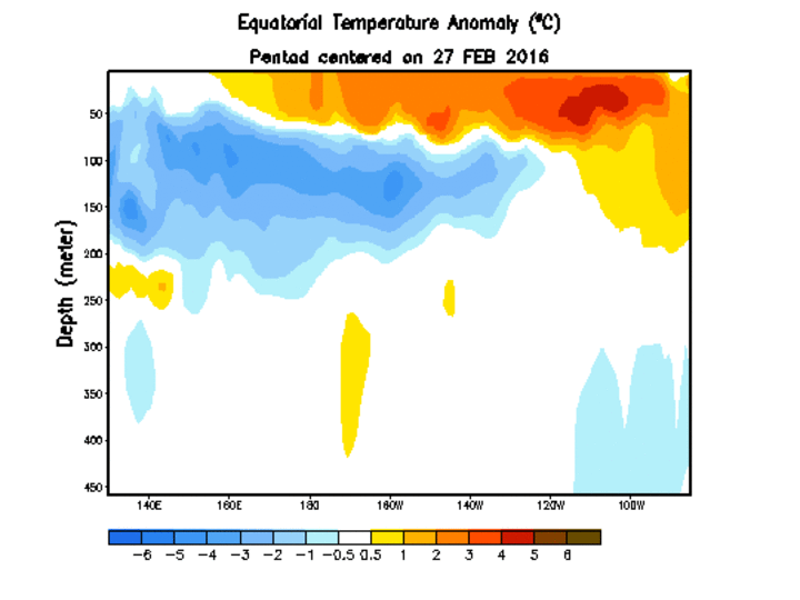
Figure 2 indicates that the depth of cold water underneath the surface extends from Australia to South America, so there is plenty of support for continued cooling in the eastern Equatorial Pacific. The consensus of the various models in Figure 3 indicates that the average (yellow line) moves into La Nina territory in the July-September period. If we don't consider the five models that keep the equatorial Pacific basin on the warm side of average through the end of the year, then the consensus line drops into La Nina conditions during the June through August period.
If cooling in the last 30 days is indicative of the future, there will be no El Nino signal by mid-June and I wouldn’t be shocked to see La Nina conditions develop by early July. Although moisture trends are quite favorable now, a building La Nina usually brings above normal summer temperatures and a drying trend that usually strengthens as summer wanes across the western Corn Belt.
Much of this mid-spring wetness is the result of upper air lows that are cutting off over the central and southern Rockies, then slowly drifting into the central and south central United States. Copious Gulf of Mexico moisture is being drawn into these systems as they slowly advance eastward. Precipitation totals have been heaviest across the western Corn Belt, weakening east of central Iowa where high pressure over the eastern U.S. has limited the eastward advance of these upper air lows.
I believe many of these lows that are cutting off can be directly tied to the current El Nino event rapidly weakening. Considerable energy has been entering the northwestern U.S. through the polar jet, but has weakened as it moved into the central Rockies. The northern jet and a weakened southern jet (usually strongest during El Nino) have been insufficient to aggressively push these lows across the country.
Since the Equatorial Pacific is cooling so rapidly, the southern jet should continue to weaken throughout May and early June. There should be less frequent cut off low development as more energy is directed into the northern jet. The summer forecast then becomes dependent on mean position of the northern jet and where Nebraska lies in relation to the northern jet.
If the mean position of the northern jet the past three weeks remains consistent through the summer, Nebraska lies in a promising position. When one of these cutoff lows passes east of the state, we immediately move into a northwest flow aloft regime. This is the type of pattern that brings frequent clippers through the state, resulting in widespread thunderstorm development along the leading edge of the cold front. We also usually see above-normal wind and hail events with this pattern.

Further east, much of the upper Midwest would lie north of this current mean position and drier-than-normal conditions would be expected. However, if the northwest air flow sets up further east, Nebraska would be west of the jet core and experience drier and hotter weather. Above normal moisture would be likely with Iowa and Illinois located in a much more favorable jet position that would increase the chances of frequent cold fronts and thunderstorm activity.
Short To Mid-Term Forecast
After another round of heavy moisture this past weekend, it appears that we are likely to see dry conditions hold through Friday. Yet another large upper air low looks poised to swing out onto the Plains sometime this weekend. Precipitation may develop as early as Saturday across western Nebraska and Sunday in eastern Nebraska. Precipitation could occur through Tuesday, May 10.
Although current models don’t advertise further cutoff upper air lows in the short term, a string of weaker systems are predicted every couple of days through mid-May. This continued moisture is likely to mean continued planting delays for some. Delays are most likely in areas south of I-80 where the heaviest moisture fell the past three weeks and soils have a greater clay component.
Based on the inability of the northern jet to push systems across the country, I anticipate that the active weather pattern will continue through the second half of May as the mean trough over the western U.S. shows no sign of breaking down. Severe weather events may begin to increase in the western US as the northern jet becomes the dominant jet pattern; tornadic weather across the southern Plains would be expected to wane.
Summer Forecast
Since the current El Nino event is dissipating so fast, we will need to closely monitor weather conditions this summer in anticipation that warmer drier conditions will strengthen as the summer unfolds. Recent soil moisture increases due to increased precipitation events will give us a little room to handle drier-than-normal conditions as long as moisture doesn’t completely shut off.
The good news regarding potential drought conditions this summer is that snow continues to accumulate across the central Rockies as each of these upper air lows churns slowly eastward. We will end this snow season with normal to slightly above normal snowpack in the central Rockies, which should help slow the western upper air ridge’s move east, which is usually a harbinger of drought development across the western Corn Belt.
I still anticipate that some of the central and eastern Corn Belt will continue to battle drier than normal conditions prior to corn pollination. If La Nina conditions begin to strengthen the northern jet, as presently forecasted, then statistics say that a wetter than normal trend will develop during the second half of the summer across the eastern Corn Belt. The big question will be whether enough dryness develops to limit yields during the first half of the growing season. If this La Nina event unfolds as anticipated, I would expect a drier pattern to develop in the western Corn Belt the second half of the summer, intensifying during the early fall.
The eastern Corn Belt should experience a wetter pattern in late summer and early fall. This is a common La Nina signal and can play havoc on fall harvest activities, as well as increasing the odds that soil will enter the 2017 planting season with excessive moisture prior to spring planting.
