After an exceptionally warm and dry start to March, a powerful storm system moving across the country dropped significant snowfall accumulations from eastern Colorado through northern Michigan mid-week. Heavy snow accumulations were reported in Colorado, Nebraska, South Dakota, Iowa, Minnesota, Wisconsin, and Michigan. On the southern side of the storm, severe weather was reported in southeastern Nebraska, southern Iowa, and northern Missouri.
Preliminary snowfall totals from this system ranged from nothing across southeast Nebraska to over a foot in northeast Nebraska. The greatest reported snowfall totals were 15 inches at Hubbard (NeRAIN Network) and Wakefield (NWS Coop Site). Most snowfall totals were in the 2-8 inch range from southwest through central and north central Nebraska. Northeastern Colorado snowfall reports approached two feet in the headwater region of the Republican river, so a temporary surge in streamflow rates would be expected if melting is rapid.
Above Normal Moisture, Below Normal Temperatures Through Mid-April
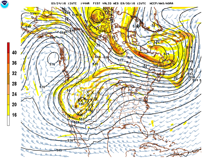
Figure 1. View of upper air pattern forecast for 6 a.m. March 30 showing a big upper air trough over the Rockies and moving into the Plains March 30. (Source: National Weather Service)
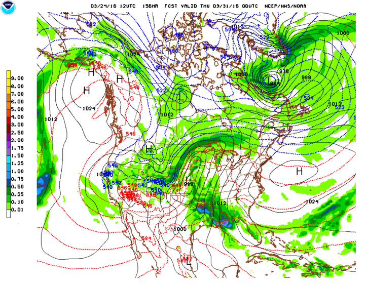
Figure 2. Surface moisture and temperature patterns forecast for 6 p.m. March 30. The darker green area outlined from southwest to north central Nebraska indicates a line of heavier precipitation. The red lines indicate above-freezing temperatures, while the blue lines indicate below-freezeing levels. The scale indicates precipitation equivalent forecast for the 12-hour period from 6 a.m. to 6 p.m. March 30. (Source: National Weather Service)
March 23 Storm Numbers
Snow Accumulation (inches)
Wakefield: 15
Newport: 6
Hubbard: 15
Valentine: 5.5
Wayne: 14
Chambers: 5
Stanton: 13.9
Stapleton 4.9
Norfolk: 9
North Platte: 4.3
Neligh: 8.5
Bloomfield: 4.2
Ericson 8
Mullen, O’Neill: 4.0
Butte: 6.4
Arthur, Big Springs, McCook, Ogallala: 3
Precipitation totals reported to NeRAIN ranged from 0 at many sites to 1.07 at Enders and 1.15 inches at Lamar.
This marks the second storm system to impact Nebraska in the last 10 days and appears to be the start of a period of above normal moisture and below normal temperatures that could continue through the first half of April. Medium range weather models indicate several opportunities for strong low pressure systems to cross the central Plains and an increasing likelihood that another Arctic air intrusion will enter the north central U.S. the first week of April.
A quick moving system will move across the state on Saturday, but precipitation amounts are currently projected to be less than a quarter of an inch and will primarily be in the form of rain. A brief period of snowfall is possible on the backside of the system late Saturday night through early Sunday morning. Warm air will quickly return to the central Plains by Sunday afternoon and will continue through March 29 in advance of another powerful storm that is expected to develop over the central Rockies.
Weather models indicate that the central Rockies storm system will begin to move out on the High Plains by late Tuesday afternoon March 29 and spread moisture across Nebraska on Wednesday, March 30. The National Weather Service’s Global Forecast System (GFS) model takes this storm on a nearly identical path as this week’s snow storm, so it would be advisable for ranchers to keep a close eye on this system for its potential to create problems for calving operations.
As this weather system moves into the western Great Lakes, the GFS model shows a strengthening of the upper air low by deepening it and pulling Arctic air southward on its backside. The worst of the Arctic air is projected to impact the Dakotas eastward through the Great Lakes April 1-3. Eastern Nebraska appears to catch the brunt of the cold air and lows may dip into the upper teens to low 20s if the GFS verifies.
A rapid warming trend is then forecast for April 5-7 as an upper air low moves into southern California, pushing the western U.S. upper air ridge eastward. The GFS model takes this upper air low and moves it rapidly to the northeast on April 7, intensifying it over southern Nebraska on April 8. If the GFS model is correct, this system will lack enough cold air to generate snowfall, but severe weather potential could be elevated.
A couple of additional storm systems are projected to move through the central Plains April 9-15, however model accuracy this far in advance is questionable. If we are to believe current weather models, rain and thunderstorm due to a lack of cold air being drawn southward from Canada would be the primary impact. Unfortunately, if these weather systems verify, we will likely be dealing with wet surface conditions for the USDA Risk Management Agency (RMA) initial planting dates for insured crops: corn (April 10 and April 15), soybeans (April 25), and grain sorghum (April 16 and May 6). (See all earliest planting dates for insured crops covered in Nebraska.)