Traditional irrigation decision-making relies heavily on experience and requires frequent visits to the field. The process is time consuming and labor demanding, while the results are not quantitative and prone to error.
A new Web tool uses the science of crop simulation crop modeling and information technology to help make smarter irrigation decisions with less effort from producers. CornSoyWater (Figure 1) is an online app for corn and soybean that predicts whether irrigation is needed using precipitation data and the seven-day forecast. The recommendation is based on predictions of
the amount of crop-available water currently in the soil,
crop stage and stage-based irrigation threshold, and
the possibility of crop water stress at present and in the near future.
Users receive those predictions, in numerical values, from their computers or mobile devices without going to the field. The app also helps producers schedule their work more efficiently by showing the fields that need attention for irrigation.
What does it take to use CornSoyWater?
A user must open an account at cornsoywater.unl.edu by clicking on the yellow Sign Up button. CornSoyWater is free.
Registering a field is simple.
Choose between Corn or Soybean.
Mark the field location directly on the Google map.
Specify the following:
Crop maturity
Planting date
Plant population
Maximum soil rooting depth
Percent of soil surface covered by residues
Soil moisture condition at planting
You will need to do this only once in a season.
What does the prediction for a field look like?
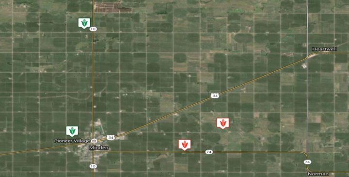
Figure. 2. Upon login of CornSoyWater, the map shows all registered fields with green color to indicate fields without need for irrigation and red to indicate fields that may need irrigation.
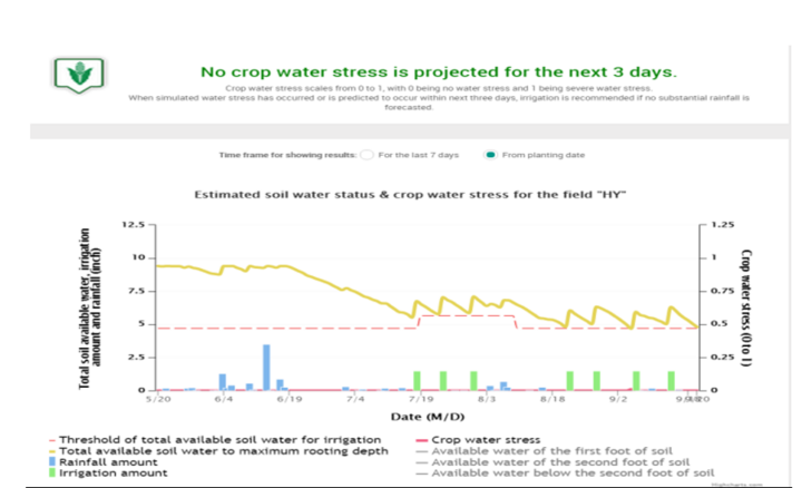
Figure 3. Predicted total available water in root zone (yellow line), threshold for irrigation (dotted red line), rainfall (blue bars), and user input irrigation events (green bars). X-axis shows calendar date, left Y-axis shows water amount, and right Y-axis indicates water stress (the red line that has been 0 for this field).
Upon logging into your account, all the corn and soybean fields you’ve entered will be shown on a Google map with either green or red colors: green indicates no need for irrigation while red indicates a need for irrigation (Figure 2). To see detailed predictions for a field, users can click the symbol for that field. A new screen will open and display a graph of estimated soil water status and crop water stress for that field (Figure 3).
Whenever the crop-available soil water amount falls below the threshold for irrigation or the crop is under water stress, the program will recommend irrigation if no significant rain is expected in the next three days. The message is displayed at the top of the screen (Figure 3).
The program also will show an up-to-date summary of:
Amount of available water in soil root zone
Available water in soil root zone at planting
Total rainfall since planting
Total irrigation amount
Total crop water use (i.e., actual ET)
Total water losses (non-ET losses)
How does CornSoyWater work in the background?
CornSoyWater uses crop simulation models (Hybrid-Maize for corn and SoySim for soybean) to predict crop growth, development, crop water use, and soil water balance. Based on the location of the field, the program automatically determines
the weather station that is closest to the field in the weather station network, and
the soil texture for the field.
Each time the user logs in and selects a field, the program will make a prediction regarding the need for irrigation (Figure 3), using up-to-date weather data for that field and other crop and soil information the user provided at field registration. When the user irrigates a field, the irrigation date and amount must be entered into the program so the next prediction will reflect the irrigation.
These videos can help guide first time users through creating an account, entering initial field data, and interpreting the results.
Summary
CornSoyWater provides irrigation recommendations in real time mode, based on a quantitative prediction of
amount of available water in the soil root zone along with stage-related threshold for irrigation, and
possible crop water stress.
It also summarizes
up-to-date water inputs (rain and irrigation),
crop water uses and losses, and
overall water balance.
Users get those up-to-date predictions without going to the fields.
CornSoyWater is current being evaluated using data from irrigators’ field and research plots. Irrigators and crop consultants are encouraged to try it out and send their comments and feedbacks to the developers. Potentially, this software could be implanted into irrigation control modules for automated irrigation control, variable rate irrigation, and other irrigation decision supports packages.
References
Setiyono, T., Cassman, K.G., Specht, J., Dobermann, A., Weiss, A., Yang, H., Conley, S.P., Robinson, Andrew P., Pedersen, P., and De Bruin, J.L. 2010. Simulation of soybean growth and yield in near-optimal growth conditions. Field Crops Research. 119, 161-174.
Yang, H.S., Dobermann, A., Lindquist, J.L., Walters, D.T., Arkebauer, T.J., and Cassman, K.G. 2004. Hybrid-maize ― a maize simulation model that combines two crop modeling approaches. Field Crops Research. 87, 131-154.