According to the Nebraska Agricultural Statistics Service, the start of the fall harvest season has begun in earnest. As of September 18, two percent of the corn and soybean acreage had been harvested. With temperatures soaring into the 80s and 90s this week, we would expect these harvest numbers will have increased by the next report Monday, especially for soybeans.


We can be thankful that most of the heavy precipitation has fallen across areas to the east and northeast of Nebraska. The most recent event brought 2-10 inches of moisture to southern Minnesota, northern Iowa, southern Wisconsin, and northern Illinois. This area is one of the regions that USDA was projecting to be a major contributor to their national record corn yield projection last month.
Even with the large percentage of tiled ground in this region, it will likely take at least a week of precipitation-free weather and above normal temperatures for producers to have a reasonable chance of getting combines back into fields without causing significant compaction issues. Unfortunately, this area is in the crosshairs of the next two major atmospheric troughs that are projected to move across the country over the next 14 days.
The system projected to move through the region this weekend will likely renew flooding concerns for Iowa as quantitative precipitation forecasts put out by the weather models indicate a widespread area of 2-4 inches there. If this system shifts further north, a substantial portion of the areas hit with heavy rain during the middle of this week will experience additional flooding rains.
Nebraska appears to be located on the western periphery of this wet area and forecasts indicate the heaviest moisture will likely develop across the eastern third of the state. This week’s weather models have tended to move the heavy moisture east and north with each successive model run. On Monday the precipitation forecast was showing 2-3 inches across most of eastern Nebraska for this weekend. Totals as of Thursday morning had been reduced to 0.10 to 1.25 inches, with the heaviest totals across extreme southeastern Nebraska.
More importantly, the weather models are pointing toward an extended dry pattern through the end of September. Temperatures are forecasted to be below normal next week as the upper air low responsible for this weekend’s precipitation is forecasted to cut off over northern Minnesota and slowly drift eastward into the upper Great Lakes region by next Friday. Cool air will flow into the Central Plains on the backside of this low and temperatures may struggle to reach the 70s until mid-week.
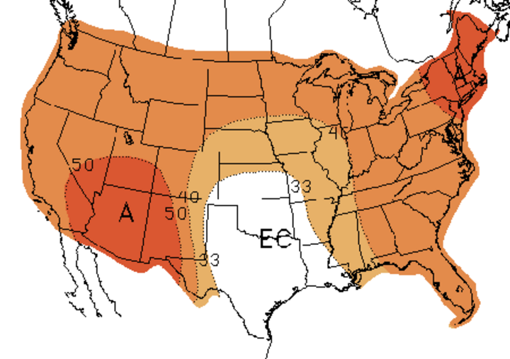
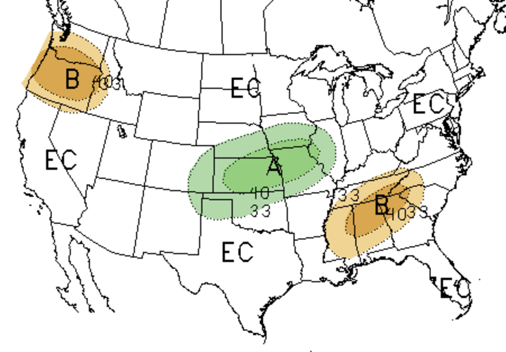
Taking a longer look at the weather trends for October, the Climate Prediction Center indicates that the southeastern half of Nebraska is expected to experience above normal precipitation. The northwestern half of the state has no defined precipitation tendency. There is a slight tendency for above normal temperatures statewide. My personal opinion is that the most likely area for above normal moisture will be across the same areas that have been aggressively wet for the last three months — the upper Midwest and northern portions of Iowa and Illinois.
Further out into the fall and winter the outlook becomes more questionable. For the better part of the last nine months the Climate Prediction Center has had a forecast of La Nina conditions developing as the fall progressed. CPC pulled back their La Nina watch because sea surface temperatures have remained static and haven’t shown signs of cooling the past two months. In addition, their newest model package indicates that further cooling of the Pacific Equatorial region is unlikely this fall.
It should be noted that the Southern Oscillation Index used by the Australian Bureau of Meteorology has recently moved into La Nina territory. This is the time of the year when most La Nina events begin to strengthen rapidly, so it will be interesting to see which agency forecast for this region produces the more accurate forecast. At this time I continue to believe that we will experience La Nina conditions, only weaker than initially forecasted this spring.
Therefore, the most likely forecast with La Nina conditions would be a movement toward cooler than normal conditions this winter. Precipitation will be much more difficult to project, but I would be inclined to place the upper Midwest through the eastern Corn Belt into an area likely to experience above normal moisture.
If the precipitation does come to fruition, there could be widespread areas with major flooding concerns during the late winter through spring planting period. Soils are already saturated and there is no room for additional moisture. Fall harvest and tillage operations and nitrogen applications, both in the fall and spring, would likely be affected.
