Tracks of May 6 Tornadoes and Rain Storms
Heavy rain and tornadoes were the main impact from the numerous storms that moved through southeast Nebraska May 6. These storms provided rapid and continued tornado development on the southeastern edge of the storm cells.
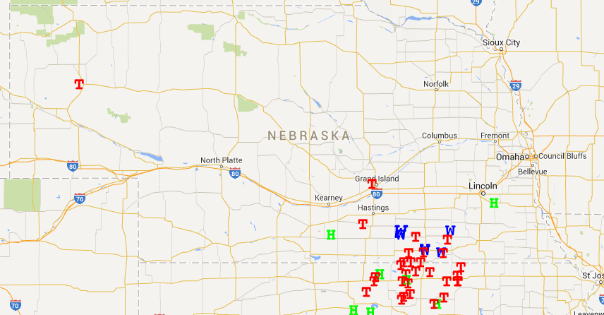
According to the Storm Prediction Center "Preliminary" Storm Reports, there were 13 reported tornadoes in Nebraska, which included a brief touch down just west of Alliance in Box Butte County. The first tornado in Nebraska was reported around Roseland in Adams County and tornado warnings continued for the rest of the evening through southeast Nebraska. Tornado damage was reported in Adams, Nuckolls, and Thayer Counties with potentially more tornado damage in other counties. There were few reports of hail or non-tornadic wind associated with the storms, thus the focus was first on tornado damage, then the threat of flooding.
A strong upper level trough over the southwest U.S. provided the foundation for the large storm system. A surface low was situated in eastern Colorado and western Kansas and slowly progressed north and east. Low-level moisture transport from the gulf and strong mid/upper-level winds provided the moisture and instability needed for quick-developing supercells and tornadoes.
The heavy rainfall amounts were primarily due to the slow east-to-west propagation of the front, with storms moving from southwest to northeast along the front. This created a scenario where these storms continued to move over the same area for a number of hours. Precipitation amounts varied, but 5-10 inches was estimated in a line from Superior to Lincoln, with locally higher amounts reported. The possibility of severe storms was mentioned a few days in advance, but the event "exceeded expectations", according to the National Weather Service in Hastings.
The heavy rainfall associated with the system will continue to impact areas well after the storm. Many of the rivers and streams were at or above capacity shortly after the storm. Increased flows will continue, especially in the main confluence areas. Low lying areas will remain ponded for quite some time, especially with precipitation in the forecast for the next few days. The best chance of precipitation for southeast Nebraska comes on Saturday into Sunday.
Tyler Williams
Extension Educator

There were 13 reported tornadoes in a fairly narrow area of Nebraska May 6 (see larger map). See national map tracking Map 6 tornado activity. (Source NOAA Storm Prediction Center)

National Weather Service map shows May 6 precipitation through southeast Nebraska. (Source: National Wether Service)
