Last Weekend's Storms
A powerful upper air low slammed much of the central and southern High Plains with an abundance of moisture April 28-30. Significant rainfall was reported across broad swaths of southern Kansas and northern Oklahoma. To add insult to injury, heavy snowfall followed the rainfall from the Texas Panhandle through north central Nebraska.
Unofficial reports indicate 12-24 inches of wet snow fell across southwest Kansas and southeastern Colorado leading to fears of significant damage to the wheat crop, which was in the heading stage. Further north in Nebraska, unofficial reports of up to 10 inches of new snow were reported by NERain observers in the Sumner and Arapahoe areas. Snow totals of 3-8 inches were common from southwest through north central Nebraska.
Rainfall reports were also impressive in Nebraska, with much of the area south of I-80 reporting 1.5-3.0 inches. Unofficially, the greatest reported moisture with this system in Nebraska was 4.13 inches 9 miles northwest of Ord (both melted snow and rain). Thankfully we didn’t experience the extremes witnessed across northeast Oklahoma and southern Missouri, where 6-12 inches of rainfall occurred and there was significant flooding.
Drought Conditions Dry Up
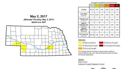
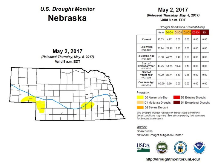
Major improvements are reflected in this week’s U.S. Drought Monitor. In Nebraska, the area of the state in drought plunged from 23.3% of the state in drought or with abnormally dry conditions last week to just 5.0% in abnormally dry conditions this week. Two areas of the state were rated as abnormally dry: the southeastern Panhandle and southwest corner of the state north of Imperial and an area in southern Nebraska. The latter still has over a six-inch deficit when the annual precipitation trend is considered.
Forecast for the Upcoming Week
It will certainly take several days of drying before most soils across the state are fit for planting, but recent models do indicate a window of opportunity for producers to make headway with their planting. The short-term forecast offers a return to normal temperatures by the end of this week.
The upper air low responsible for our late April storm event has now moved into the eastern U.S. In its wake, high pressure will gradually build into the central United States through this weekend. The front that moved through Nebraska on Tuesday strengthened south of the state, deflecting moisture to our east and southeast. This will likely increase planting delays for the south central and eastern Corn Belt.
Once we get into next week, the weather models are less clear about precipitation. Weather models do hint of very weak chances of moisture across central and eastern Nebraska on Monday and Tuesday, but no more than a few scattered light showers are expected. Next Wednesday (May 10), models indicate a series of systems are expected to eject out of a trough moving through the western United States. If this verifies, then another stretch of heavy rainfall should be expected for the central Plains between May 11 and May 16. This would likely lead to another round of planting delays.
