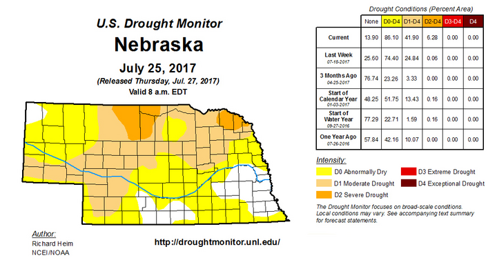
Widespread moisture finally fell across north central and northeast Nebraska July 25-26. Although the moisture was quite welcome, it likely will not result in modifications to next week’s Drought Monitor. This broad area of the state has been consistently dry during the past 30- and 60-day periods, with percent of normal moisture values running under 50%. Extreme northeast Nebraska has received less than 25% of normal moisture over the past 30 days.
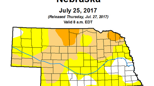
The area in drought or abnormally dry conditions in Nebraska increased in this week’s U.S. Drought Monitor, particularly in the northern half of the state, reflecting the lack of moisture and distinct stretches of temperatures exceeding the mid 90s. (The July 25-26 precipitation occurred after the 7 a.m. Tuesday cutoff for the weekly Drought Monitor data.)
The latest weather model runs are beginning to show signs that precipitation chances may become more favorable for the western third of the state through the middle of next week. This may lead to possible easing of dry conditions, particularly across the Panhandle. Additionally, highs are forecast to be more seasonal through the end of next week. This projected increase in precipitation would be by monsoon moisture flow into the central High Plains, coupled with moisture surging northeastward from tropical systems working their way northward off of the Baja Peninsula.
Models indicate that the upper air ridging pattern that frequently brought extreme heat to the central and northern Plains the past two months will be centered over the western third of the U.S. At the same time, the jet stream will favor a northwest flow regime through the middle of next week and small pieces of energy will periodically move over the state, placing Nebraska directly under its path. Tropical moisture surging northeastward out of the southwestern U.S. should interact with the northwest flow regime to enhance precipitation chances.
Models indicate that thunderstorm development is most likely across the Panhandle on Saturday, moving further into western Nebraska on Sunday. Monday and Tuesday chances decrease slightly, but scattered afternoon thunderstorm development will still be possible across the western third of the state. As the upper ridge begins to shift eastward, isolated to scattered thunderstorm development may shift into the eastern half of the state, but model output doesn’t show widespread moisture.
By the end of next week, the upper air ridge will have moved far enough eastward to bring temperatures into the 90s; however, the models don’t show widespread extreme heat in the upper 90s and low 100s like we’ve seen in the past month. Models indicate that an upper air trough will move into the Pacific Northwest next weekend and that it will deepen and slowly move eastward August 7-11.
As the Pacific Northwest upper air trough deepens, monsoonal moisture advection will move northeastward into the central Rockies and increase precipitation chances for the western half of the state through periodic thunderstorm activity. Unfortunately, models are not aggressive with their moisture depiction for the eastern half of the state, so further deterioration of drought conditions is possible, barring an unexpected outbreak of thunderstorm activity.
Although this forecast is based on the latest model runs, forecasts the past two months have overplayed precipitation events that eventually became a bust. Conversely, the models under forecasted some of the concentrated heavy rainfall that occurred in isolated pockets across the state the past two weeks. Still, for Nebraska, this represents the most aggressive forecasted precipitation pattern for western Nebraska since early June. For eastern Nebraska unfortunately, the precipitation forecast is not very optimistic.
