Weather Update Early April 2015
Storms Offer Little Precip, Drought Areas Start to Increase
April 3, 2015
The first round of severe weather struck Nebraska during the evening hours of April 1 as a line of thunderstorms developed ahead of a cold front that swept through the upper and central United States. This line of thunderstorms extended from western Lake Superior southwest through north central Kansas at its peak. Unfortunately, thunderstorms only developed in the eastern third of the state, resulting in another missed opportunity for much needed moisture to stem intensifying drought conditions in western Nebraska.
The upper air low associated with the April 1 event lagged the surface low and another round of precipitation developed during the afternoon of April 2 over northeastern Colorado and southeastern Wyoming. This system headed southeast overnight and brought light precipitation to the southern Panhandle and the southern half of the state. There was enough cold to turn the rain to snow across parts of the southern Panhandle, west central and southwest Nebraska.
April 1 precipitation ranged from 0.50 to 2 inches east of Grand Island and south of Columbus. The heaviest totals were reported across southeast Nebraska with Dewitt reporting 2.23 inches. A pocket of 1 to 1.50 inches fell from southern Thayer County northeast through northern Gage County. An area with similar precipitation totals fell from northern York County through central Sarpy County.
The April 2 event resulted in widespread light precipitation. South of Interstate 80 precipitation ranged from 0.10 to 0.35 inch. North of the interstate, precipitation totals dropped to a range of trace to 0.10 inch. Unfortunately, these totals were insufficient to make any dent in the dry condition that have been persistent since early February.
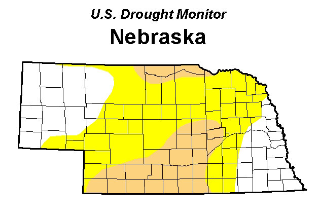
Because of this extensive dry period, this week the US Drought Monitor expanded the area of moderate drought conditions across portions of southern Nebraska. Moderate drought conditions were pulled northward from extreme southwest Nebraska to cover most of southwest, south central, and central Nebraska. Further north, a small sliver of moderate drought conditions was pulled southward from the eastern Dakota's to cover the northern tier of counties from just east of Valentine to the junction of the Niobrara and Missouri rivers.
There appears to be a subtle shift in weather models in relation to short-term (two weeks) overall jet stream pattern. Weather models are migrating toward a western US upper air trough bringing energy into the central and northern Rockies. The 16-day Quantitative Precipitation Forecast currently indicates the potential for 2-6 inches of moisture across the southern two-thirds of the state, with totals rapidly dropping off to less than an inch along the Nebraska-South Dakota border. Widespread precipitation totals in excess of 6 inches are predicted for the eastern Corn Belt and water-logged southern Ohio River valley region.
If this forecast for generous moisture comes to fruition, and that's a big if, it should provide limited relief for drought-stricken southwest Nebraska. Unfortunately, heavy moisture across eastern Nebraska could result in less than ideal planting conditions for areas that experienced heavy moisture from late August through early October. The area most susceptible areas include the York, Mead, Lincoln, and Omaha areas where current soil moisture values indicate field capacity has been reached down to the four-foot level.
Preliminary snow pack estimates indicate a significant decline over the past month for the southern and central Rockies due to very dry March conditions. Once the data is released by the Natural Resource and Conservation Service early next week, we will provide a detailed analysis of potential impacts. In addition an examination of atmospheric weather factors that have the potential to impact crop yields across the county during the upcoming growing season will be provided.
Al Dutcher
Extension State Climatologist
Online Master of Science in Agronomy
With a focus on industry applications and research, the online program is designed with maximum flexibility for today's working professionals.
