weather-forecast-8-14-15
Rains Forecast Over Next 10 Days
Aug. 14, 2015
Weather models indicate numerous opportunities for measurable precipitation during the next 10 days as several strong upper atmospheric troughs move across the northern Plains. The first systems is projected to slide through the region this weekend and generate thunderstorm activity along the surface cold front that will slide southeast out of the Dakotas. The best opportunity for moisture appears to be across northwestern Nebraska from Saturday evening through Sunday morning. This area then shifts to the eastern half of the state from Sunday afternoon through Monday morning.
One weather model indicates thunderstorms could continue into Tuesday morning across eastern Nebraska; however a couple models hint at the cold front clearing the state by Monday with dry conditions building into the central Plains through Wednesday afternoon. Depending on the model, another cold front is projected to move through the state between Wednesday afternoon and Saturday morning.
The second cold front is currently projected to bring well below normal conditions to the northern Plains, possibly reaching as far south as central Kansas. If this cold front verifies, a period of active thunderstorm development is likely during the second half of next week. As the cold air shifts to our east, monsoon moisture is projected to return to the Plains the last full week of August, which would bring additional chances for moisture across the western Corn Belt.
The most recent quantitative precipitation forecast for August 14-20 calls for a broad area of 0.75-2.75 inches across Nebraska. The highest precipitation totals have been assigned to central and northeast Nebraska with amounts of 1.50 to 2.75 inches. East central, southeast, and south central Nebraska are currently projected to receive 1.00 to 1.50 inches. Further west, precipitation forecasts are for 0.50 to 0.75 inch across the Panhandle and 0.75 to 1.50 inches across southwest and west central Nebraska.
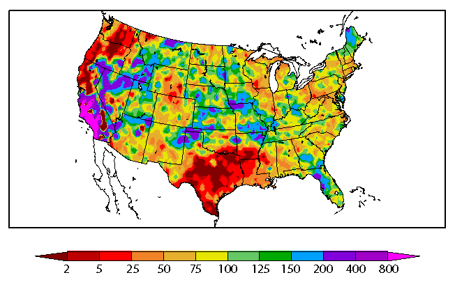
More importantly, much of Iowa, Illinois, Indiana and Ohio are projected to receive less than 0.75 inch of moisture across areas that were impacted during the first half of the growing season by excessively wet conditions. This would be on top of past 30-day trend where a substantial portion of the eastern Corn Belt received less than 50% of normal moisture. It will be interesting to see what impact this developing dry pattern will have on corn yields, since producers have been lamenting about the how shallow rooted the corn crop is in areas that received the brunt of flooding rainfall from May through mid-July.
Al Dutcher
State Climatologist
Online Master of Science in Agronomy
With a focus on industry applications and research, the online program is designed with maximum flexibility for today's working professionals.
